
Geodata | General
Geodata are digital data that can be assigned to a geographical location and are thus clearly related to spaces. As a rule, this involves specific points or areas of the earth's surface.
Geodata defines locations, boundaries and areas and, in combination with spatial features, provides an overview of landscape and demographic structures. Geodata can be used to depict information on companies, locations, sites, infrastructure facilities, target groups, customers and much more on maps. For this reason, they are a valuable tool for a successful marketing or sales strategy, the planning of regional sales potential, products or branches and numerous other entrepreneurial measures.
Geodata is processed in various formats: it forms the basis for digital maps and navigation applications, but can also be linked, compared and evaluated in geoinformation systems. Factors such as quality, quantity, availability and timeliness are decisive for their usability.
Spatial structures
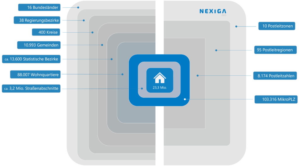
Nexiga's market data is available immediately or within a few days on the basis of both official (administrative) and postal levels, as indicated in the figure. We will be happy to inform you individually about the delivery possibility of other structural levels on request.
In addition, if a desired feature cannot be found here, we will respond to special requirements at any time. Of course, the data will also be adapted to desired room structures. Please simply contact us if you have any questions.
Micro level Building - the lowest common denominator
The territorial structures of the Federal Republic of Germany are divided either according to official (administrative) or postal levels. In both systems, the Building forms the smallest common unit. With Nexiga KGS and Nexiga Zip code our geodata are available on both bases. Depending on your requirements and wishes, all geoinformation can also be output on the basis of individual territorial divisions - with unchanged quality and topicality. We are happy to take your company's own structures into account.
The individual Building offers the finest spatial classification of our geodata on the basis of both Zip code and KGS. More than 300 features with up to 1000 characteristics are broken down to the more than 28 million buildings in Germany and thus represent the smallest unit of measurement in geomarketing from which particularly precise insights can be gained.
The Building (KGS44) provides the finest spatial level in spatial planning.
Official territorial levels
KGS (picture on the left)
is based on the official territorial structures designated by the 8-digit county municipality key number (KGS).
- Federal state (KGS2; 1st and 2nd digit)
- Administrative district (KGS3; 3rd digit)
- County (KGS5; 4th and 5th digit).
- Municipality (KGS8; 6th to 8th digit).
- Statistical district (KGS12)
- Statistical district part (KGS16)
- Neighbourhood (KGS22)
- Street segment (KGS36)
- Building (KGS44)
Postal area levels
Zip code (picture on the right)
corresponds to the specifications of Deutsche Post and is based on logistical and spatial distribution aspects.
- Postal code zone (ZIP CODE1)
- Postal code region (ZIP2)
- Postal code (ZIP CODE5)
- Micro postal code
- Postal location (PO)
- Post Office Part (POT)
- Building (KGS44)
With KGS, your geodata is broken down according to the eight-digit County-Municipality key number (KGS). The 16 federal states of Germany (KGS2) form the coarsest grid of the official territorial structure.
Municipalities (KGS8)
All of the approximately 11,300 municipalities are defined by means of the eight-digit key number KGS8. The key thus simultaneously enables assignment to all higher levels such as County (KGS5), Administrative district (KGS3) or Federal state (KGS2).
Statistical districts (KGS12)
Below the municipal level, the hierarchical logic is continued. The approximately 13,700 statistical districts in large and medium-sized cities (KGS12) provide a further relevant and official level of classification.
Residential quarters (KGS22)
Based on the official voting districts, approximately 88,000 residential quarters (KGS22) contain an average of 500 households each with the greatest possible homogeneity. The residential quarters therefore offer an ideal analysis grid that is fine-grained, segmentation-strong, statistically stable and easy to visualize in maps.
Road sections (KGS36)
The approximately 3.2 million street sections (KGS36) are based on a current, area-wide street directory and form the second smallest level before Building. They combine certain house number ranges within an Postal code , usually the odd or even house numbers on one side of the street. Each Street segment contains all hierarchically superior official keys and can therefore be clearly assigned to a higher level, such as an Neighbourhood or statistical district.
Zip code complies with the specifications of Deutsche Post and classifies the available geodata according to logistical and spatial aspects.
Postal code (ZIP CODE5)
The five-digit Postal code is part of the postal address and limits the delivery location of letters, parcels or packages. In addition to the postal codes for geographical delivery areas, there are separate postal codes for large recipients and post office boxes. Deutsche Post AG, the successor to the Bundespost, is responsible for assigning new postal codes.
Micro postal code
The approx. 100,000 microPLZs represent the postal counterpart to the residential districts in the official classification compared to the KGS. The new fine-grained and homogeneous street and residential area grid offers companies the opportunity to improve the planning of relevant target areas many times over.
.