
From Network Planning to Satisfied Customers
Solutions for the telecommunications market
Expand networks strategically. Build a successful sales organization.
From a White Spot to a Hot Spot
Neue Kunden zu finden ist in der Telekommunikationsbrache eine anspruchsvolle Aufgabe – denn die Zielgruppen sind riesig und absolut inhomogen. Hinzu kommen gesättigte Märkte und ein starker Wettbewerb. Der einzige Weg, hierbei die Übersicht zu behalten führt über hochwertige Daten und detaillierte Analysen.
- Where should the next expansion take place?
- Which buildings offer potential?
- And how do you reach the households that are a good fit for your offering?
Nexiga combines geographic and market data with your own customer and network information. This allows you to identify where a more detailed analysis is warranted, which areas you can prioritize, and how planning and sales work together.
Key Points at a Glance
- Evaluating Areas for Expansion: Considering Buildings , Households, and Existing Broadband Services Together.
- Planning Networks: Spatially integrating addresses, building geometries, and parcels.
- Identifying Customer Potential: Pinpointing Target Audiences and Selecting Sales Territories More Strategically for Successful Door-to-Door Sales.
- Compare Locations: Use catchment areas, competition, and customer base to plan your store.
We know where your customers are online.
Sie benötigen spezielle Telekommunikationsdaten, um Versorgungslücken zu erkennen, Ausbau- und Absatzpotenziale zu bewerten sowie Marketing und Vertrieb gezielt zu planen. Das gelingt durch die Verknüpfung von Kabel- und Glasfaserverfügbarkeiten, Mobilfunkversorgung sowie Haushalts- und Zielgruppenmerkmalen. Folgende Fragen können so gezielt beantwortet werden:

-
Where is there potential for network expansion?
Data on broadband and mobile network availability reveal gaps in coverage. Household and building data help assess the potential for connections. -
Which households are particularly receptive to high-speed Internet?
An interest in home streaming, high-speed Internet, and multimedia services helps narrow down relevant target groups geographically. -
Where is targeted marketing worthwhile?
The combination of available infrastructure and target audience affinities shows where suitable offerings meet potential demand. - and much more...
Where do you see your next opportunities for growth and customer acquisition?
Ein Gebiet mit vielen Haushalten ist noch kein wirtschaftliches Ausbaugebiet. Entscheidend ist, wie sich mögliche Anschlüsse, vorhandene Angebote und Ihr eigener Kundenbestand zueinander verhalten – und vor allem, welche Ausbaukosten durch die erforderlichen Anschluss- und Leitungslängen entstehen.
Mit Nexiga Daten und dem passenden GIS machen Sie diese Zusammenhänge auf der Karte sichtbar. Sie verknüpfen Informationen zu Gebäuden und Haushalten mit Breitbandverfügbarkeiten und Ihren eigenen Daten. Damit entsteht eine Grundlage, auf der Sie Ausbaugebiete vergleichen und Ihre nächsten Schritte begründen können.
Select Development Areas Strategically
Find out how many households and businesses are located in a given area and what broadband services are already available there. Based on your cost and revenue assumptions, you can determine which areas you should examine more closely first.
Better Assess Buildings
Consider a building's usage, number of households, and number of floors together. This allows you to assess the potential for connection and prepare for further evaluation of the building's infrastructure.
Align Sales with Relevant Opportunities
Identify areas where your offering resonates with the right target audiences. Additional market information will help you tailor your campaigns and sales activities to these areas.
Reach the Right Customers
A planned or already established network needs customers. To that end, it’s helpful to know where there is still potential and which target groups you can reach with your offerings.
Nexiga supplements your customer information with geographic market and target audience characteristics. This allows you to better categorize your customer base, compare different areas, and identify where additional sales activities would be beneficial.
What telecommunications data do you need for your planning?
Whether you want to get an overview of a region or evaluate individual buildings, the data set should be tailored to your decision-making needs. Nexiga offers telecommunications characteristics for this purpose, market data as well as supplementary building, household, and geodata. By linking infrastructure and target audience data, you can identify coverage gaps, assess expansion potential, and plan targeted sales initiatives.
What will help you take your network planning to the next level?
When a potential development area becomes a concrete project, the planning process requires a closer look at addresses, buildings, and land parcels.
Building Coordinates identify building locations. Building outlines show their floor plans. Parcel data provide additional details on the boundaries and use of the land. Together, this information helps to spatially locate buildings and identify affected areas along potential route alignments.
For indexing within a building, information on the use and households , and floors. For example, a multi-family residence can bundle multiple connections. The effort involved must be assessed based on the building’s specific conditions.
The spatial database also supports mobile network planning: 3D building models depict building heights and—depending on the level of detail—roof shapes. When combined with your own location and network information, you can analyze building surroundings and refine your planning.

How can we prioritize expansion areas, evaluate buildings, and increase connection rates?
This article shows how Nexiga uses address, building, household, and geodata to support the cost-effective planning of fiber-optic network expansion—from site selection and route planning to targeted pre-marketing and network densification.
What makes parcels of land so valuable?
Flurstücksdaten zeigen die genaue Lage und Grenzen einzelner Flächen. Nexiga ergänzt diese um Angaben zur Flächennutzung und zur Einordnung als privat oder öffentlich.
Damit können Sie Glasfasertrassen präziser planen und betroffene Flurstücke eindeutig zuordnen, um zugehörige Eigentümerinformationen gezielt abzufragen.
Das erleichtert die Vorbereitung von Genehmigungen und hilft, Umwege sowie zusätzliche Baukosten zu reduzieren.

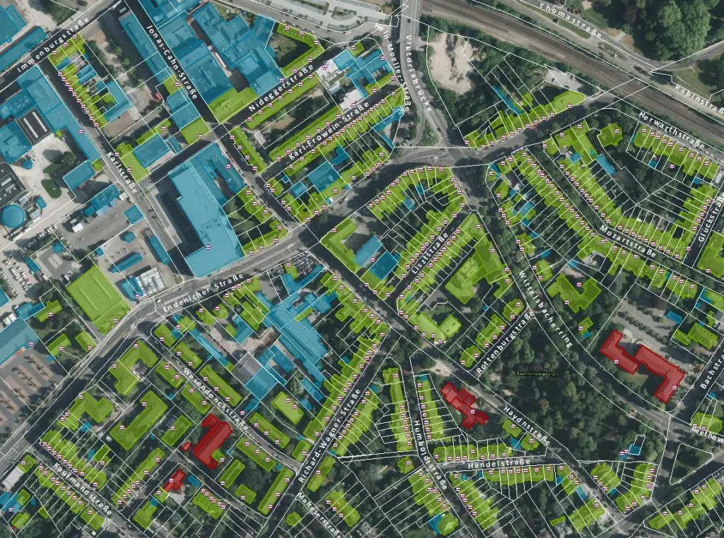
Do you need geographic and 3D data for seamless wireless network planning?
Nexiga provides geospatial data for evaluating terrain, development, and sites for your network expansion. This includes aerial imagery, surface data, parcel boundaries, building outlines and heights, as well as 3D building models at the LoD1 and LoD2 levels of detail.
LoD1 represents buildings as simplified block models, while LoD2 also takes roof shapes into account. This information helps you assess the spatial conditions for your wireless network planning.
In addition, Nexiga offers specialized data from the database of its partner, Hexagon. This data is based on Hexagon’s comprehensive aerial survey program. The combination of geographic and attribute data provides a solid foundation for your network and site planning.
How Your Data Can Become a Reliable Basis for Decision-Making.
You provide your research question and the information you have. We'll help you put together the appropriate data set and analysis.
First, we’ll work together to determine what decision you’d like to make and which area is relevant to it. Next, we’ll map your addresses and add appropriate attributes to them. Finally, maps and analyses will show how potential opportunities, customers, and competitors are distributed.
Depending on your needs, you can use Nexiga data in your existing systems, work with our geoinformation software, or have us analyze a specific issue for you.
For many years, Nexiga has been helping telecommunications companies evaluate expansion areas, identify market potential, and pinpoint the geographic locations of target audiences. This is based on industry-specific data that integrates information on infrastructure, coverage, and demand.
Tip: Link your CRM data to Nexiga’s market and geographic data. Using spatial analysis, you can identify service gaps, prioritize areas for broadband expansion, and evaluate locations for new stores. At the same time, you can identify where relevant target groups live and the customer potential that results from this.
Using a GIS (Nexiga Market Analyst), telecommunications companies can also assess existing coverage, identify target groups, and recognize opportunities for network expansion and sales.
Frequently Asked Questions About Telecommunications Data
How can you effectively plan for the potential of new stores and network expansion?
Spatial planning tools (such as Nexiga Market Analyst Pro) use the right data to reveal customer structures and market potential, thereby providing visual support for store planning and strategic network expansion.
Can I enrich my customer addresses with external data?
Your customer addresses can be linked to relevant market and geographic data through a shared spatial reference. To do this, the addresses are, for example, geocoded—that is, assigned coordinates. The specific attributes that can be added depend on the data package and the reference layer.
Which expansion areas offer significant customer potential with limited competition?
By combining Nexiga building and household data with broadband availability and target audience characteristics, it is possible to identify areas with high connection potential and currently low coverage and prioritize them for network expansion planning.
How can customers be segmented effectively?
Enriching your own customer data using the Nexiga Enrichment Server with industry-specific attributes gives you insight into detailed customer profiles and enables targeted marketing.
How up-to-date is the data, and at what geographic level is it available?
The data status varies depending on the characteristic and source. For broadband availability, for example, the date of the survey should be taken into account. We will work with you on a case-by-case basis to determine which data is current and appropriate for your specific needs.
Where can we find households with a strong preference for fiber-optic internet and high-speed internet?
For example, the Nexiga Technology Scores indicate affinity for high-speed Internet, home streaming, and high-tech products. Together with additional information, such as household data, they help narrow down the geographic scope of target audiences for fiber-optic service offerings.
How can we use data and analytics flexibly and scale them to meet our growing needs?
Our DaaS solution provides a scalable, future-proof approach to data and analytics that delivers lasting value to businesses and meets their specific needs. Learn more here.
Do I need building-specific data for every analysis?
For an initial regional overview, an analysis at the Municipality —or Zip code —level is often sufficient. Building-level data is particularly helpful if you want to evaluate individual properties, development clusters, or small-scale sales territories. The level of detail required depends on your specific decision.
Data
Data is the basis for a successful future. The most important thing here is to enrich your own CRM data with high-quality market and geodata. Gains in knowledge guaranteed.
Software
Recognize potential, seize opportunities, minimize risks - use our geoinformation systems for maximum location, target group and market insight.
Analyses
Be where your customers are. Sell where your products are needed. Know more wherever you want. Our experienced experts are at your side with suitable analyses.
Use Cases
Knowledge starts here. Our download center contains detailed information on every product. From case studies to data catalogs. Take a look, download.
Questions about our solutions?
Do you need a results-oriented solution for your industry? Are you looking for specific data characteristics or would you like to receive more information? Then simply use our contact form. We are looking forward to your questions!