Geodata from the geo expert
Recognize spatial relationships and use them profitably.
The "Where is Where" - Spatially to the Point, Thanks to Precise Geodata
Geodata defines the "where" and represents added economic value in many industries and sectors. You can use them to find out whether there are spatial correlations between your existing customers, where potential new customers are located and how advertising measures can be planned more precisely. In addition to consumer-relevant market data, geographic data provides information on companies, locations, sites, infrastructure facilities, target groups, customers and much more. They are visualized on digital maps for planning purposes. Geodata defines exact locations, boundaries and areas and, in combination with other features, provides an overview of spatial and demographic structures.
Geoinformation is available on the basis of individual area classifications (geometries).
Thanks to digitization, street layouts, city boundaries and the location of certain buildings can be used in a multivariable way. They provide information about development plans, broadband usage or even hunting districts. They show industry concentrations in federal states all the way to purchasing power by city districts, streets or even individual houses.

Pinpoint market analyses and location-specific sites
This means for every geographical point the possibility of a house-exact representation. The acquisition and calculation of structures, geometries and coordinates in microgeography are among our strengths as geomarketing experts.
Precise and efficient routes to the next location or precisely defined advertising and sales areas provide you with important indications for your planning. Due to the linking of geodata and the detailed information on market data such as purchasing power, age, marital status, building type, individual areas can only be described in detail.
Inquiry without obligation is always possible!
Geocode geodata
It will be easier for you to see the connections. Because it is only through geocoding, i.e. the identification incl. linking of detailed information on topics such as income classes, family structure or lifestyle with the associated geodata, that individual areas can be described in detail and with pinpoint accuracy and related to each other on maps. I.e. organize target areas with coordinates and geo keys according to addresses or distribution zones.
A fine-spatial and segmentation-strong analysis grid like the Micro postal code scales spatial boundaries just as they are useful for planning. Concrete determination of sales or delivery potentials or improved mapping of neighborhoods are major advantages here. In addition, it can be applied to the Sinus-Milieus®.
Use many advantages
- Geodata is essential for your location and store planning as well as in the development of apps, online map services and 3D city models.
- In logistics, they allow the optimization of traffic routes and delivery routes, and in the planning of radio networks, WLAN hotspots or power lines, they are an important basis.
- You can choose between the classification according to Zip code-areas or according to official area structures. And if you want to know exactly, the coordinates of the individual house represent the smallest unit for the spatial reference in geomarketing.
Precise planning with the Micro postal code
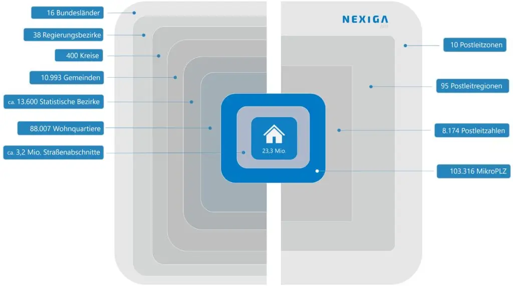
The Micro postal code combines the official and postal worlds. It is the fine-grained and highly segmented analysis grid that transforms your planning areas into relevant target areas. An average of 450 households become a homogeneous grid. This makes the Micro postal code much more accurate than the usual five-digit zip codes and other area units in the market. Identify sales and sales potential more precisely and map neighborhoods better. This is how location intelligence works.
- 103,316 areas in total
- Sharper than the Zip code 5
- Absolutely comprehensive
- An average of 450 households


