Not every customer who lives five kilometers away can be reached in five minutes. That is precisely why choosing the right routing method is crucial to the quality of a location analysis.
With the newly developed Nexiga Marktanalyst Online, users benefit from a modern user interface, improved usability, and powerful analysis features. These include a flexible routing function that allows catchment areas to be calculated realistically based on the road network.
Instead of simply using the distance as the crow flies, the routing algorithm takes into account the actual accessibility of a location. Road layouts, turn options, and traffic regulations are factored into the calculation, thereby providing significantly more reliable results for location analyses, sales territories, or market potential assessments.
With our Nexiga Market Analyst Online, you can quickly and easily define a catchment area for a location and identify potential based on market data.
-
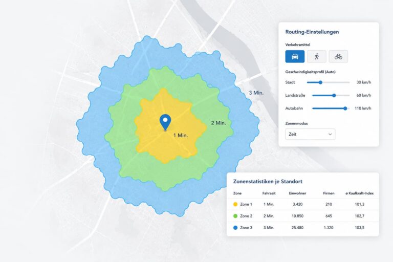
Incidentally, 4 km/h is generally assumed for pedestrians and 18 km/h for bicycles. The navigation rules for cars (such as one-way streets or turning regulations) do not apply here.
WebGIS is ideal for small to medium-sized businesses in a wide range of industries.
Would you like to learn more about Nexiga Marktanalyst Online?
In a short video, we’ll show you how to calculate realistic catchment areas along the road network, define travel time zones individually, and thoroughly assess the accessibility of your locations. With Nexiga Market Analyst Online, you can make better decisions regarding location, sales, and expansion.
Get results in just a few clicks
-
1. Select a location: Search for and locate the desired location, such as Mozartstraße 4 in Bonn.
-
2. Start the potential analysis: Add the location to the analysis by clicking “Add to Potential Analysis.”
-
3. Define the catchment area: Select the routing mode to calculate realistic catchment areas based on the road network.
-
4. Configure routing: Specify the mode of transportation, speed profile, and travel times for the analysis.
-
5. Set travel time zones: Define the desired catchment areas, e.g., 1, 2, and 3 minutes.
-
6. Select analysis parameters: Determine the geographic level and the relevant variables, such as population, businesses, and purchasing power.
-
7. Start the calculation. Select analysis parameters: Optionally, name the analysis and start the potential calculation.
-
8. Visualize Results: Customize the map background and layers to best present the results.
-
9. Evaluate potential: The catchment areas and key metrics are displayed directly on the map and in the table.
-
10. Customize symbols: Use symbols to clearly display catchment areas and easily compare locations.
This short demo video shows you, step by step, how to create routing zones in Nexiga Marktanalyst Online.
Feature Tip
The standard profile with city (30 km/h), country road (60 km/h) and highways (110 km/h) is suitable for locations outside conurbations or outside times of heavy commuter traffic. Lower values are recommended within conurbations or at times of heavy rush hour traffic, e.g. city (15 km/h), country road (30 km/h) and highways (70 km/h). These average values take into account all traffic light stops or temporary gridlocked traffic. The values can be flexibly adjusted for each category.
Flexibly adaptable to any traffic situation
Nexiga Marktanalyst Online allows you to evaluate locations based on realistic vehicle catchment areas. First, select the desired location and add it to the potential analysis.
The routing mode calculates catchment areas along the road network and flexibly adapts them to different traffic conditions. By selecting relevant analysis parameters from market and structural data—such as population, businesses, or purchasing power—the system generates insightful potential analyses that are clearly visualized on the map and can be used to make informed location decisions.
For cars, for example, average speeds can be set individually for city traffic, rural roads, and highways. This allows routing to be optimally adapted to different conditions—such as rural areas, metropolitan areas, or rush hour traffic. The results are clearly displayed on the map and in tables and can be customized using different symbols for visualization and used to conduct informed location assessments.
The standard profile is suitable, for example, for normal traffic conditions outside of heavily congested areas. In cities or during rush hour, average speeds can be flexibly reduced so that traffic light stops or slow-moving traffic are realistically factored into the travel time calculation.
Greater accessibility – better chances of success
With Nexiga Marktanalyst Online, companies can define realistic catchment areas in just a few seconds and combine them directly with comprehensive market, target audience, and structural data.
This makes potential visible where it is actually attainable—a crucial foundation for well-informed decisions regarding location, sales, and expansion.

27.07.2026
Jochen Wetzel has been part of the Nexiga team for more than 25 years and is one of the most experienced experts in site and regional planning as well as location intelligence. He advises companies across a wide range of industries on strategic issues related to site analysis, competitive analysis, and data-driven decision-making.