With a house number, an address often becomes an address, a defined geographical location in a country, a city or a district. In modern societies, these are very important for recipients of letters and parcels or for broadband connections. For location intelligence applications, they are primarily used for precise positioning for geoanalysis.
Around the world, there are many different systems for arranging or assigning house numbers. Even within Germany, there are some variants and special features for house numbers, which we will look at in more detail in this article.
Parisian-style house numbers
The first house numbers existed over 500 years ago. As early as the 15th century, the 68 houses on the Pont Notre-Dame - a bridge in Paris - were numbered, and from 1519, the houses in Augsburg's Fuggerei, one of the oldest existing social housing estates in the world, also had numbers.
House numbers were introduced on a larger scale to number houses in the 18th century in order to enable clear orientation, addressing and locating of a building. The predecessors of today's house numbers were the house numbers introduced by Maria Theresa in Vienna by imperial patent in March 1770. conscription numbers.
With the Paris system we are most familiar with, which works like a zipper system. The numbering starts at the end of the street facing the city center on the left side with 1 and on the right side with 2 and then runs separately according to even and odd numbers to the other end of the street. Due to the different sizes of the properties, it often happens that numerically adjacent numbers are not opposite each other in reality.
Berlin-style house numbers
The Berlin system on the other hand, shows a circulating house numbering system, like a horseshoe. The numbering sequence begins on one side of the street with 1 (or with the first house number that appears), continues without interruption to the end of the street and then back on the other side of the street. In smaller villages, the houses are often simply numbered without street names.
From the outside, the Nexiga office at Mozartstrasse 4 - 10, Bonn, is basically a large building. buildingunder which several house numbers are grouped together. However, a house number 6 or 8 or their (original) building parts are not visible from the outside.
As for geoanalyses and geocoding house numbers in the USA are often based on the base number of a street block (e.g. 1000) and show the distance to the starting point of the block (in feet or meters) as in a coordinate system. One of the best-known house numbers is probably 1600 Pennsylvania Avenue in Washington DC, where the "White House" is located.
house numberstossentences a different way
In general, if there are changes in the building stock and there are no more free house numbers available, house numbers are often supplemented with an addition. The addition is usually a letter, for example the classic house number 1b or 7a. Sometimes, however, it can also lead to a new numbering for a section of the street. This is always necessary after a plot of land has been divided, when gaps between buildings are closed or when an additional Building is built on a plot of land that is independent of the main building.
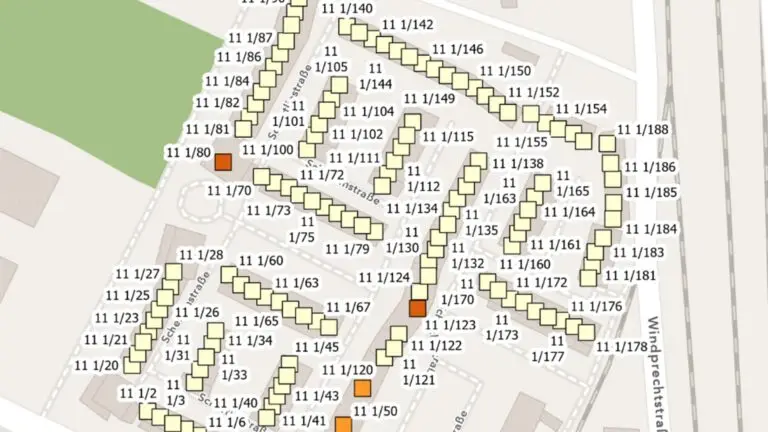
A special feature as a house number add-on are so-called fractional numberssimilar to the fictitious track nine and three quarters at King's Cross station in London from the Harry Potter world. Although this fractional number system is rather rare in Germany, it is all the more impressive in some cities such as Augsburg.
In the southwest of Augsburg, for example, there is a Neighbourhoodwhich contains almost only buildings with fractional numbers with fractional numbers. Starting from Building with the number 11 on Schertlinstraße, a complete new development area with more than 130 buildings was built without introducing new street names. All the houses were given fractional numbers, from 111⁄2 up to the number 111⁄188.
Our map shows the buildings from the Nexiga house database for this neighborhood, as well as the characteristic "number of households" per building with corresponding color classification.
> Click here to open the map (PDF)
The precise mapping of the different house number systems for our geomarketing solutions as well as for the geocoding is an important database for the precise localization of address data. With the Nexiga Geocoder can be used to check and validate your own address databases by post. The system solution accesses over 28 million address data, approx. 2.3 million street sections including coordinatesand official and (micro-) geographical geocodes (references to geographical units). Through the enrichment with geo-keys (data enrichment), addresses can be linked to a wide range of market data, displayed on informative digital maps and used for a variety of spatial analyses.
You can find more information about house coordinates here.