Location Intelligence as an Entersprise Solution
Professional site and territory planning for your business.

The solution kit for strategic decisions
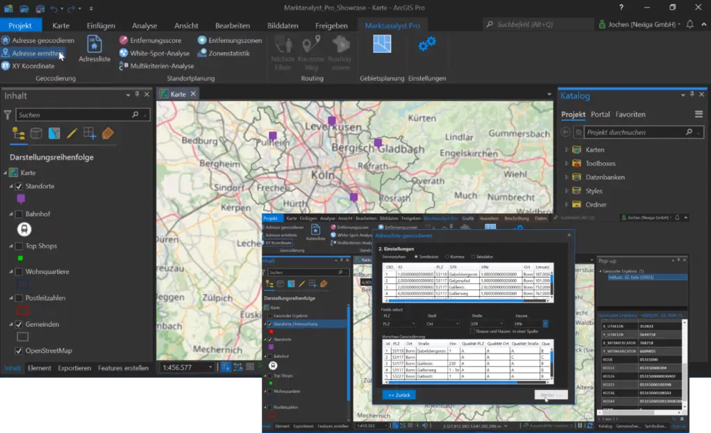
The Nexiga Marktanalyst Pro - the desktop solution for spatial issues - offers you the unique combination of (geo) data and software. It guarantees you independence and security on the basis of ArcGIS Pro, the world's leading GIS software from Esri Inc. Numerous functions for the basic software refine your applications and analyses - whether for location or area planning, e.g. as part of your expansion.
Find new and attractive locations and target groups for your store or the top class among your sales areas. With Nexiga Marktanalyst Pro, you can quickly and easily discover expandable white spot areas. Simply determine your customer and sales potential in the catchment area over different distance zones - the application possibilities are manifold. We support you with our experienced team of experts in integrating the GIS software into your corporate IT.
THE MAIN ADVANTAGES
Leading desktop system
Current market and geodata
Geocoding
included
Extensive analysis options
Online resources in access
Lots of possibilities!
- Targeting
Knowing in which regions the right target group can be found is part of every marketing department. How high the purchasing power is in a certain area or in which postal codes a young or old population structure lives, can be transferred to the map by filtering and selecting the corresponding market data in your table with a direct selection.
- Customer potential analysis
How your customers or prospects are distributed spatially, locally or regionally, and whether geographic patterns are discernible in this regard, is displayed by importing the address list of your existing customers into the system. The data is validated ad hoc in the system, assigned a coordinate and projected directly onto the map for further analysis and visualized as customer density. In this way, you can easily identify the potential areas that are of interest to you, taking into account potentials such as purchasing power or social milieus.
- Analyze and evaluate environment
The potential for new customers around a planned or existing location quickly becomes apparent when several distance zones around one or more stores are created according to various criteria. Meaningful statistics (key figures) make it much easier for you to compare locations objectively and to make the right decision when selecting a location.
- Hot spot analyses
Which areas can be identified by statistically significant spatial clusters with high values (hot spots) and with low values (cold spots) is shown by the hot spot analysis. The basis for the analyses are events that can be derived from your company data: New customer acquisition, lost customers, complaints, sales figures/coverage contribution (per customer) or delivery attempts (parcel logistics).
- ... and much more
What our customers say:

Multi-criteria analysis
Evaluate sales opportunities
Which areas offer the best sales opportunities for a particular product or service, and are there any spatial patterns?
A multi-criteria analysis evaluates spatial units (e.g., Zip code areas or fine-grained residential quarters) by simultaneously combining several criteria (market data), optionally with different weightings. The score value shows, for example, how strongly a certain target group or the proportion of people with high purchasing power is represented. The residential quarters are shown on the map with the help of a ranking according to the value.
White spot analysis
Discover potential areas
Stores or other points of interest have an impact on their surroundings, depending on their importance both on a small scale (e.g. bakery) and on a large scale (e.g. furniture store).
The attractiveness of a location decreases with increasing distance. The further away an area is from the nearest location, the less it is served by the location in terms of coverage and accessibility. However, if there is a high potential there, spatially possible gaps in the existing store network can be discovered, so-called white spot areas for expansion planning.
11 helpful tutorials for Nexiga Market Analyst Pro!
Don't leave spatial questions unanswered. Based on ArcGIS Pro, the world's leading GIS software from Esri Inc., we show helpful tips on how to use Nexiga Market Analyst Pro in numerous tutorials. Functions such as geocoding, routing and white spot analysis are just a few examples.
PRODUCT FEATURES
In combination with the already existing functions of ArcGIS Pro, the Marktanalyst in the Pro variant reproduces all known functions of the previous desktop variant (for ArcMap). Get an overview of which useful features the Marktanalyst Pro provides for you.
| PROPERTIES | |
|---|---|
| Users |
flexible |
| Terms | From 12 months |
| Basic data (at the level of the micro Zip code and residential quarters) |
|
| Functions | Geocoding
Site planning
Hierarchical territory planning
Other
|
| Customizing | We customize the system to your individual needs on request (as a service). Ask us about further functions and possibilities. |
| Database Add On |
Based on our housing stock of around 28 million buildings in Germany and over 300 characteristics, you can select the information you need for a qualitative analysis of your market. |
Exchange 45 minutes of your precious time for precious knowledge.
In this video recording of our last webinar, we show you novelties and special features that make up a professional GIS software.


You have a free choice of data characteristics.
With Nexiga Marktanalyst Pro, Nexiga provided wide-ranging data packages that can be individually integrated into the system.


