Highways are the main arteries in the road network and often allow relatively fast and safe progress. In the age of e-mobility, the accessibility and availability of fast charging stations along the highways is a must for many travelers in order to cover longer distances safely.
Our nationwide analysis shows in which sections the supply of fast chargers is already excellent and where there is still a need for optimization.
Freeways in Germany
With a length of around 13,200 kilometers, the autobahn network in Germany is the fourth longest in the world. In terms of Europe, however, Spain has the longest highway network with more than 15,600 kilometers, according to DESTATIS. France follows in third place.
The term "autobahn" was first coined in 1929, as a kind of counterpart to the railroad. The world's first highway-like road was opened back in the early 1920s, the famous AVUS (Automobil-Verkehrs- und Übungsstraße) through Berlin's Grunewald forest. At that time, it was 8.3 kilometers long and subject to tolls. Today it is part of the A115 in southwest Berlin.
A first precursor of the autobahns we know today was opened between Cologne and Bonn in 1932: The Rhineland Provincial Road ("Kreuzungsfreie Kraftfahr-Straße") was 20 kilometers long and was later considered a diplomatic route in West Germany for the former capital. Today, it is part of the busy A 555. Also interesting: The A 831 at the Stuttgart interchange is officially the shortest highway, with a route length of only 2.3 kilometers.
In terms of traffic volume, the A 100 in Berlin is the busiest highway, basically an inner-city urban highway in Germany's largest city. It is followed by the A 3 in the area of the eastern part of the Cologne ring road and the A5 in the area of the Frankfurt western interchange.
The German highway network is set to get a little longer. The Ministry of Transport recently announced the construction of an additional 988 kilometers, around 7.5 percent of the existing network. In addition, highway projects are to be accelerated for areas with traffic jams and bottlenecks in order to make traffic flow more smoothly.
Our data on the topic of e-mobility
Nexiga provides answers to questions about e-mobility and charging infrastructure. How will the increasing number of e-cars affect the networks? How many e-vehicles are already in my network area, how many will be there in the next few years, where will charging stations be needed, where will bottlenecks arise?
The same principles apply to the planning of charging stations as to the location planning for other facilities. In addition to car registration figures at various geographical levels, car frequency data, public parking spaces and their capacities, and top stores - our comprehensive chain store database - naturally play a role.
You can find out more about the energy industry solutions here.
Analysis of the accessibility of fast charging stations
The other day on the highway: A hint of spring was in the air on this sunny day, towards evening the setting sun colored the sky fire-red, and the 8 Tesla Superchargers on the service station grounds at a rest area on the A61 in the Hunsrück region also shone in a similar color. Some of the power charging columns were occupied, presumably the drivers were at the fast food restaurant across the street.
Fittingly, the small town of Stromberg is located very close to the service area. Because of the name, one could almost assume that e-mobility was invented there, which is of course nonsense. It would be equally nonsensical to regard the image of an ordinary service station for internal combustion engines, supplemented by a few charging columns, as typical of the future. Of course, the charging station infrastructure is much more decentralized, with everything from charging at the wallbox at home, in the office parking garage or at the supermarket.
But the principle of filling stations along important routes such as highways will remain. In the summer of 2021, for example, the most frequently used charging stations were to be found along important vacation routes. On average, drivers should find a fast-charging station every 60 kilometers at rest stops and car stations.
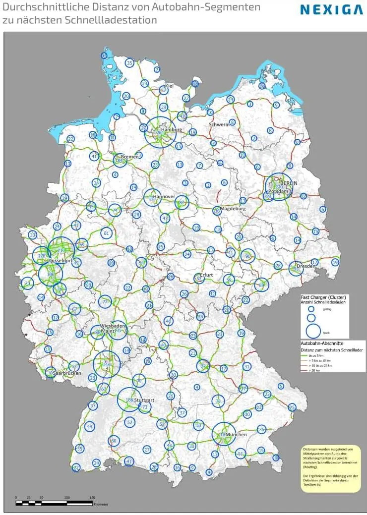
Our analysis map (PDF) shows the distance for more than 120,000 small highway segments to the nearest fast-charging station. Freeway segments colored green show good accessibility or supply of fast chargers, while in the red-colored sections you have to drive longer. In addition, the spatial distribution of the approx. 6,400 fast chargers in total is shown. As expected, clusters are found in the densely populated metropolitan regions.