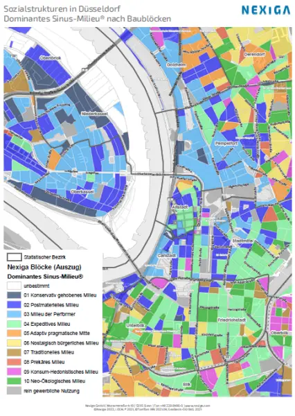
On the basis of official structures of the Federal Agency for Cartography and Geodesy BKG, Nexiga has developed a new fine-meshed block grid. Currently, 2,791,341 building blocks are geometrically mapped nationwide. As a rule, these are residential or commercial areas surrounded by roads, railroad lines or rivers.
Unlike other structures such as the Nexiga residential quarters or the Nexiga micro-Zip code, which cover the area comprehensively and without gaps, the Nexiga blocks concentrate on the actual settlement area. The blocks therefore mostly consist of built-up areas. Forests, agricultural areas, bodies of water and so on are not covered.
The concentration on built-up and populated areas offers new starting points for the analysis. Settlement cores are recognizable and the local population density can be determined and evaluated independently of surrounding open spaces.
Berlin has 28,523 blocks, Hamburg not much less at 24,863. The small town of Soest has 1,120 Nexiga blocks and Heligoland has 178, making the Nexiga blocks 10 to 100 times finer than the area grids Neighbourhood and micro-Zip code, depending on the settlement density and region. This in turn offers approaches for the most precise target group localization.
The Nexiga blocks are available as polygons in various geo-formats and map projections (coordinates).
The building blocks are gradually being filled with data on socio-demographics, typology and purchasing power. And, of course, all Nexiga building addresses are referenced to the blocks. This means that the microgeographical Nexiga Building data can also be displayed at building block level and analyzed with high precision.
Do you have questions about this special geometry? We will be happy to help and advise you. Just give us a call!