Positional accuracy - what does that mean?
Anyone who has always wondered how fiber optic expansion works may find the answer here. Official data plays a central role here.
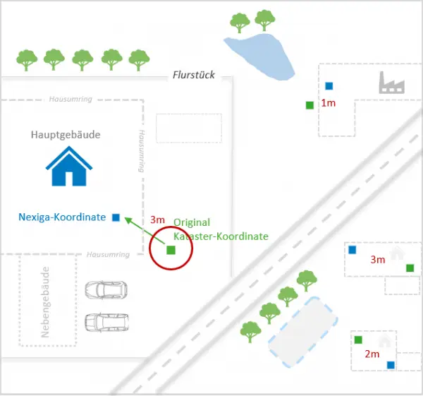
The prioritization of areas to be connected is crucial for the development of a roll-out plan. Knowing the potential of the households and companies to be supplied is essential. Without this knowledge, a solid cost estimate of such a project is not possible. Georeferenced information about the location of the buildings to be connected is therefore a sensible and valuable investment, as every meter of fibre optic expansion costs money. Obviously, the more accurate this information is, the better.
What information is this? The answer is simple: precise coordinates and house perimeters.
Nexiga generates new and independent products from official data such as coordinates and house perimeters from the ZSHH* (Central Office of the Official Land Surveying Offices). The approx. 21.5 million Nexiga house coordinates and approx. 53.5 million Nexiga house per imeters are generated nationwide via geo-processes. These can be used for a wide variety of analyses - always precisely where maximum accuracy, determination of potential and expansion are required.
The attractive price model is based on the following components.
- Intelligent Placement Nexiga house coordinates are intelligently placed in the official house perimeter and completed with further house coordinates for approx. 28 million houses.
- Corrective Placement Nexiga house perimeters are georeferenced polygons of building footprints and can be ideally combined with the Nexiga house coordinates.
- Completion Nexiga house coordinates and Nexiga house perimeters can be enriched with over 300 market information from the LOCAL® Building database.

Areas of use and applications
- Mobility: Planning charging stations
- Transportation: Number of floors (derived from the building height)
- 5G coverage: building height for 5G expansion
- Residential construction: gaps and building density for new projects
- Logistics: Delivery through precise location information of the houses to be supplied
-
Nexiga house coordinates Germany

The official house coordinates describe the location of all around 21.5 million buildings throughout Germany using their X-Y geocoordinates and the correct postal address. The data is available for all levels of location accuracy: from the official house coordinates of the national survey to interpolated house coordinates based on data from Telecom, TomTom or OpenStreetMap (Open Data). This data is used to calculate world maps or derive special maps, among other things.
-
Nexiga house surrounds Germany
 The official house perimeters represent the geometry of over 50 million building footprints in polygon form. Surveying is usually carried out individually on site, so that a high level of geometric accuracy is guaranteed. Like the official house coordinates, they are derived from the data in the real estate cadastre.
Additional information such as the building/house perimeters illustrates the building structure in many larger German city centers.
-
The official 3D building models in the LoD1 and LoD2 versions (LoD1-DE, LoD2-DE)
 The 3D building models are available for Germany in Level of Detail LOD 1. The unit LOD refers to various levels of detail in the three-dimensional design of virtual worlds. Above-ground buildings and structures are represented in the form of simple blocks with flat roofs without taking into account the actual roof shapes. The models are based on official information on building height and use as well as the building perimeter with the correct postal address. The building use is specified in great detail with up to 250 classes - from stables to classic single dwellings.
Outlook
We are currently working on the Nexiga building blocks to expand our geodata pool. Building blocks are created using geo-processes based on data from the Federal Agency for Cartography and Geodesy (BKG). The approx. 3 million Nexiga building blocks are generated nationwide for settlement areas and can be a useful unit of analysis for many applications.
Still important to know!
*ZSHH = The "Central Office for House Coordinates and House Envelopes " (ZSHH) set up at the Bavarian State Office for Digitization, Broadband and Surveying bundles selected follow-up products based on the real estate cadastre of the surveying administrations of the federal states and provides these centrally to customers on behalf of the states at uniform fee and licensing models and in uniform nationwide data formats. The ZSHH becomes active whenever users wish to license data from more than one Federal state .
