
Efficient parcel delivery with a versatile effect
At DPD Germany, parcel delivery planning was previously based on the specified zip code systems. However, due to inhomogeneity, fragmentation and size, the system-relevant structural features were increasingly becoming obstacles to efficient control, economical route planning and pre-sorting in the parcel service's local transport. In view of a daily transport volume of around 1.5 million parcels, it was not only economic and organizational considerations that had to be taken into account. Traffic congestion in city centers and communities and transport-relatedCO2 emissions also contradicted the company's declared intention to improve the quality of life in cities and communities and contribute to a healthier environment. A customized solution for efficiency and effectiveness should lead to optimized logistics.
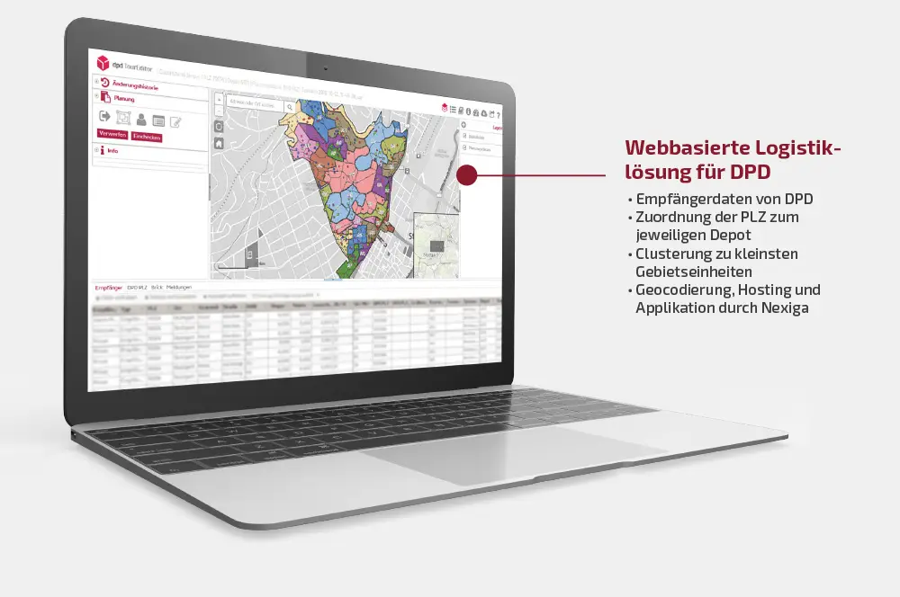
A territory planning tool as part of parcel logistics
Parcel services connect retailers and private households with modern e-commerce solutions. The consignees supplied by DPD also expect maximum service and flexibility. The order of the day was to optimize delivery logistics and reduce the volume of inner-city traffic.
A new strategic control parameter was to reorganize delivery traffic and stops and make them future-oriented. The task was to develop a graphical area planning tool that would easily adapt to the company's existing IT landscape as an integral part of parcel logistics. Territory and route planning was to be methodically redefined and implemented with the help of a customer-specific geographic information system (GIS).
New functions were to be developed to convert the conventional zip codes to "DPD parcel codes", manage tours more productively, display tour data as a PDF and make the incoming data of an entire depot scalable.
The demands on the functionality were high: informative value, intuitive, user-friendly design, round-the-clock availability, interchangeability of the data basis and linking of the tool with existing DPD systems such as TourManager, AdressHub, etc. Equally important were scalability and transferability, applicability to other depots and a ubiquitous tool character.
With an annual volume of 350 million deliveries, DPD ranks second among parcel delivery companies in Germany. With innovative technologies and a consistent focus on the needs and circumstances of all customers and consignees, DPD offers a simple, convenient and flexible service for B2B and B2C parcel shipping. One example of this is the Predict service, which is unique in the industry and offers map-based live tracking, a wide range of options for redirecting a parcel and a delivery forecast accurate to one hour.
In 78 depots in Germany alone, 8,000 employees and 10,000 delivery staff are on duty every day. Two thirds of DPD's deliveries are to commercial consignees and one third to private consignees. DPD Germany is part of the international DPDgroup, Europe's second largest parcel service network. The parent company GeoPost is a wholly owned subsidiary of the French Groupe La Poste. GeoPost recorded a consolidated annual turnover of 6.2 billion euros in 2016.

Fine adjustment of the zip code areas into smaller areas
Based on the Nexiga Marktanalyst online*, Nexiga developed an initial territory planning tool in collaboration with the responsible managers at DPD back in 2013. The tool went through several development stages as it matured: a new control parameter for local parcel traffic was defined and a graphical territory planning tool based on Java Script technology was established. The new DPD TourEditor was thus successfully integrated into the operational systems.
The previously coarse-grained zip code grid was broken up in favor of a fine adjustment. A reorganization of the previous zip code areas into smaller areas within the existing outer boundaries should make the management of DPD routes more effective and efficient.
Based on the existing zip code systems of Germany, Austria, Switzerland, Belgium and Luxembourg, new delivery areas were named with the help of an algorithm and made identifiable by means of IDs, i.e. DPD parcel postcodes.
DPD supplied consignee data and tables that made it possible to assign the zip codes to the respective depot and the tours to the respective system partners. Nexiga contributed its expertise to the development of a high-performance customized web GIS solution based on Nexiga Market Analyst online*. This included the geocoding of the company data, the map material and the calculation of the smallest territorial units (bricks) as well as the hosting of the application and the initial solution of DPD Zip code, which is based on an automated algorithm.
Optimum route planning thanks to more efficient DPD system
The company's guidelines show clear results:
- Significantly more efficient and intuitive territory planning tool
- new control variables and "DPD parcel codes
- Reduced parcel traffic volume
- Reducing CO2 pollution for cities and citizens
Since the introduction of the DPD TourEditor in the depots, it has been used by around 30 operational managers in 15 depots on the basis of the "DPD parcel routing numbers". It is expected that at peak times around 100 users will access the tool simultaneously in order to optimize their route planning and stops. The system is to be expanded in the foreseeable future with new functions and the optimization of existing features for the use of 400 to 500 simultaneous users.
Gained transparency and optimization of local transport
"With the GIS solution created by Nexiga, DPD has developed an efficient tool for planning local transport routes. The cooperation with Nexiga in the planning and implementation process is always constructive and very good."
Katharina Marthaler, Project Manager at DPD